

FREE · PRIVATE · BUILT FOR DEAD ZONES
How Camp Compass works
Install it before the trip. Mark camp before the first ride. If you get turned around, Camp Compass shows which way your saved place is and how far away it is.
THE THREE STEPS THAT MATTER
Install it. Mark camp. Watch the distance.
-
Install before the trip
Open Camp Compass while you still have service, add it to your phone, then open it once from the new icon. Allow location access.
-
Stand at camp and mark it
Wait for a location fix, press Mark this spot, name it Camp, and save it before the first machine leaves.
-
Make the number smaller
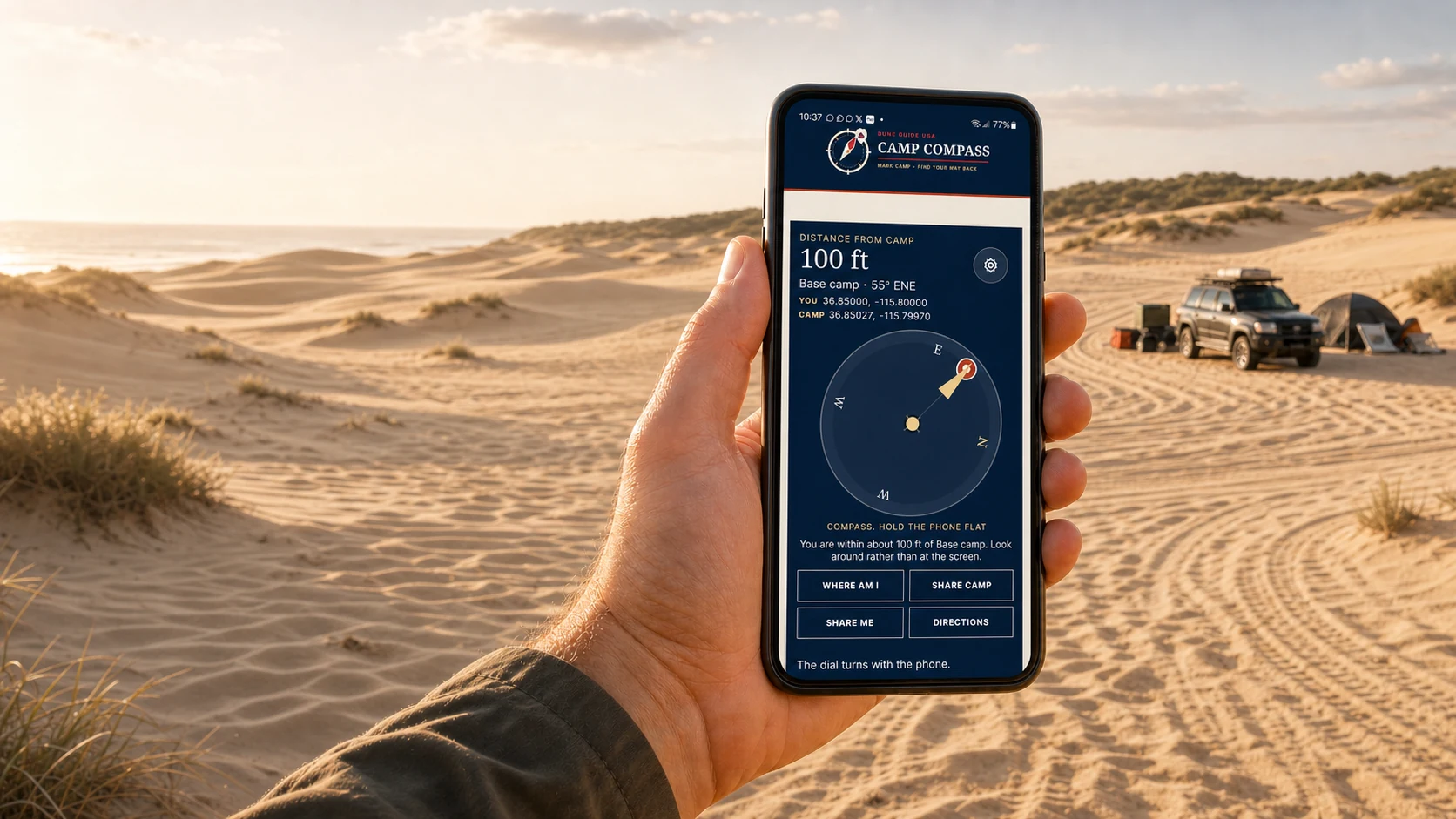
If you get turned around, line the red destination marker up with the gold arrow. Move for a short distance. If the distance falls, keep going. If it rises, turn around.
Offline use and privacy
The installed tool keeps its essential pieces on your phone. Your saved places, the downloaded Dune list, direction, and straight-line distance remain available when cellular data disappears.
Your phone supplies the location
Camp Compass asks the phone for a high-accuracy location. The browser does not tell us whether a fix came from satellites, Wi-Fi, cell towers, or a stored reading. Go outside, give it time, and check the accuracy shown in the Location box.
What still needs service
Sharing, opening a map, sending Rider Input, checking for updates, and starting a Game Mode connection need a network. Losing service does not erase camp or stop the core direction and distance display.
Your real marks stay on your phone
No account is required. Camp and your saved places stay in this installed copy until you remove them. Dune Guide USA receives nothing unless you deliberately share a place or send Rider Input.
Read the screen at a glance
The big distance is the simplest answer. Move for a short distance and look again. Falling means you are closing the gap. Rising means you are moving away.
Distance
The straight-line gap to the selected destination.
Gold arrow
The direction you are facing or travelling.
Red marker
Where the selected destination sits around you.
Source line
Whether direction comes from movement, the phone compass, or Game Mode.
Line the teardrop up with the arrow
The red marker is the destination, which is camp unless you chose another place. Turn until it sits under the fixed gold arrow, then travel that way. Confirm your choice by watching the distance fall.
Moving is more accurate than standing
Walk or ride and the source line can read Direction from your movement. Stand still and it may use Compass, the phone's orientation sensor. If the dial looks wrong, move away from metal and travel far enough for the distance to change.
Holding it flat, and when that matters
When the source says Compass, hold the phone flat and face up, like carrying a plate. Step away from the machine, trailer, tools, and other metal. When it uses movement, the way you hold the phone matters less.
If the dial will not settle
Use the distance as the check. Walk a short distance and see whether the number falls or rises. The dial and distance use different signals, so one can be unsettled while the other remains useful.
Location, destination, accuracy, and ETA
The two coordinate lines show where the phone is and where the selected destination is. Location opens the current fix and its reported accuracy. After enough readings, Camp Compass may also show an approximate time based on whether you are closing the gap or walking.
Refresh asks for a fresh fix
Press Refresh if the screen has not updated after you move or after location permission changes. It asks the phone for a new high-accuracy reading. It does not move or erase anything you saved.
Saving places
Mark this spot protects the one place that matters most. Location handles everything else. Camp Compass keeps up to twenty of your own saved places.
Marking camp
Press Mark this spot while you are standing at the trailer. It fills the name in as Camp, and one more press saves it. The button then goes away, because camp is set. It comes back if you clear camp from the menu.
Saving anything else
Press Location. A box opens with where you are. Press Save this Location, type what it is, and press it again. An abandoned car, a bowl, the gate you came in by.
The list
The Mine tab contains camp and everything else you saved. Camp stays at the top. Tap any line to see its coordinates, reported accuracy or source information, and the actions available for that place.
Pointing the compass somewhere else
Open any saved place and press Go here. It asks first, then the needle and the distance switch to that spot. Camp keeps its own line, so open it and press Go here to send the needle home again.
Camp cannot be deleted by accident
Every other place has a Remove button. Camp does not. It leaves only through Clear camp location in the gear menu, and that asks first. The way home should not be one stray tap from gone.
Clearing the rest
Clear saved locations in the menu wipes everything except camp. It asks first too. Camp is cleared separately, so neither one can take out the other.
Mark this spotSave camp from the place where you are standing.
LocationView, save, map, or share your current coordinates.
RefreshAsk the phone for a new location reading.
Go hereMake a saved or Dune location the compass destination.
MapOpen that place in the phone's map app. This needs service.
GearManual entry, Game Mode, clearing controls, guide, and updates.
Share or enter coordinatesText, link, radio, or manual entry
Coordinates travel two ways out there: as a link somebody taps, or as numbers somebody reads out loud. The tool takes both, because on a bad day the first one will not work.
Sending a place
Open any saved place and press Share. The message carries three things: the coordinates as plain numbers, a link that opens Camp Compass, and a map link underneath. Send it by text, send it in any app, or read the numbers off the screen over the radio.
Getting one by link
Tap the Camp Compass link in the message. The tool opens and shows what was sent, with the name already filled in. Change it to whatever you will recognise later, then press Save this Location. Nothing is saved until you press that.
Getting one by radio
No signal, no link, just numbers read to you. Open the gear menu and press Manual GPS Entry. Type them in and name the place. It takes them however they were read out: 43.68940, or 43 41.364 N, or 86.50920 W instead of a minus sign.
Check the distance before you save
As you type, the box shows how far away that place is and which way. That line is the error check. Drop the minus sign off a longitude, which happens constantly over a radio, and the distance reads in the thousands of miles instead of the tens. If the number looks wrong, the coordinates are wrong.
If a link opens outside the installed app
Some phones open a shared link in the browser instead of the Camp Compass icon. Those two windows may not share saved data. If that happens, copy or read the coordinates, open Camp Compass from its icon, and use Manual GPS Entry.
None of this can create camp
A place somebody sent you, or one you typed in, is saved as an ordinary location. It can never become your camp, and it never changes the camp you already have. Camp is somewhere you stood.
Use the Dune listMapped places, nearest first, available offline
Every point the network has mapped travels with the installed app. Campgrounds, gates, staging areas, ranger stations, facilities, and landmarks can be available without loading a map. The list grows as more places are checked and added.
Two lists, kept apart
Mine is camp and whatever you marked. Dune locations is ours. They never mix, because camp is the way home and it should never end up buried among a hundred pins you did not choose.
Sorted by what is closest
The dune list puts the nearest thing first and keeps re-sorting as you move. Nothing to set. If you are at Silver Lake, Silver Lake's points are at the top and Glamis is six hundred miles down the list, which is where it belongs.
The tab tells you before you tap it
The Dune locations tab reads something like help 0.65 mi · ORV Area Welcome Center. That is the nearest staffed building, on screen without opening anything. Only ranger stations, visitor centres and shops count as help. Toilets and bins are in the list, and are never the thing it points you at first.
They behave like any other location
Tap one and you get Go here to swing the needle onto it, Map to open it in your map app, and Share to send it to somebody. You cannot delete them, because they are not yours. They come back with every update.
Where each number came from
Every point shows its source under the coordinates: a BLM brochure, a published campground table, OpenStreetMap, or a survey somebody walked. Some are better than others and we would rather you could see which.
What is deliberately missing
Anything our guides call approximate, a planning pin, or a town centre stays on the website and out of Camp Compass. Those are useful for planning, not for following in the dark.
Free means freeNo account, subscription, app-store purchase, or trial
Nothing. No account, no subscription, no app-store purchase, no trial that ends. Install it directly from DuneGuideUSA.com.
We are not trying to make money from riders
Dune Guide USA carries sponsors and advertisers, and that is what pays for the guides and for this. It does not change what goes in them. A sponsor does not decide which coordinates we publish, which points we call unverified, or what we tell you about a place.
Safety information should not sit behind a paywall
Knowing which way camp is, and where the nearest staffed building is, should not depend on whether somebody paid this month. That is not the business we are in. Every coordinate here is free to every rider, including the ones who have never heard of us and never will.
Rider InputConfirm, correct, or add useful information
Open a Dune point and press Rider Input. Camp Compass prepares an email with the point, its coordinates, and its recorded source. Tell us whether it is right, off, missing, closed, or changed. Nothing is sent until you review and send that message.
A confirmation matters as much as a correction. Add your name or handle if you want credit. Approved on-the-ground confirmations can appear with the point while its original source remains visible.
How confidence is shown
- Verified on the ground. A rider stood there and confirmed it.
- Two sources agree. Two independent published sources match closely.
- Single source. Published once and not yet checked on the ground.
- Source not recorded. We do not know where the original number came from.
You are standing on it. We are not.
A rider at the gate with a live fix has better information than any published table. That is the whole reason this exists. Nothing you send goes straight into the app: somebody checks it first, because people navigate by this in the dark.
Missing beats wrong
Some riding areas still have very few verified points because approximate planning pins stay out. If a useful place is missing, send the best coordinates and description you can.
Teach your groupMake marking camp part of unloading
Make it the thing you do when the trailer is level and before the first engine starts, the same way you check the flag.
- Press Mark this spot. Standing at the trailer, not fifty yards from it. The fix is only as good as where you were standing.
- Name it. Camp fills itself in. For anything else use words you will recognise at dusk when you are tired: the truck, Wash 4, abandoned car.
- If you get turned around, watch the number. Open it, walk a minute, and look again. Falling means you are going the right way. Share the spot so everyone in the group has the same pin.
Game Mode: practise before you need it
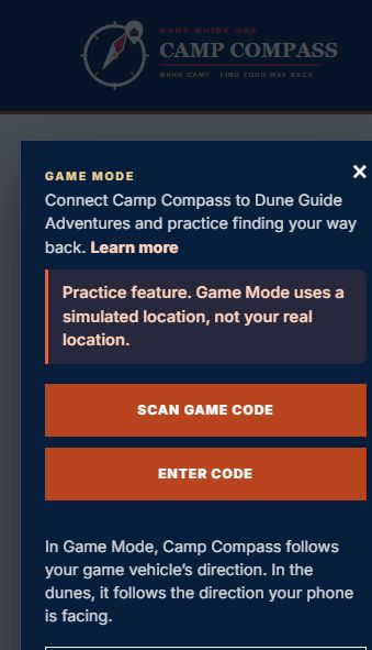
Nobody wants to learn a tool for finding camp on the night they cannot find camp. Game Mode lets you practise at home with the same phone controls.
Game Mode works only with Dune Guide Adventures. Waypoint Run is a timed gate-to-gate event and does not offer Camp Compass.
You need the installed Camp Compass on your phone and Dune Guide Adventures running on a separate desktop or laptop. Keep both devices on the same Wi-Fi while connecting.
Connect the phone to an Adventure
- Open the Arcade on the computer. Go to DuneGuideUSA.com/Arcade.
- Start Dune Guide Adventures and begin a ride. Choose a destination, area, starting point, and vehicle.
- Select I’m Lost in the game. Answer whether Camp Compass is already installed. The game creates a short-lived QR and manual code only after you select Yes.
- Open Camp Compass from its phone icon. Select Gear > Game Mode > Scan Game Code, or choose Enter Code and type the six characters.
Start the guided practice
When the phone connects, it asks New to Camp Compass? Choose Start Practice for one instruction at a time, or Skip Tutorial if you already know the tool.
- Mark and name camp. Learn what the red camp marker, dial, Location, and Refresh controls mean.
- Drive away and find camp again. Turn the vehicle, line camp up with the top of the dial, and return while the distance falls.
- Open Dune, Game, and Mine. See the difference between mapped dune points, simulated game places, and locations from real rides.
- Open Gear. Review Manual GPS Entry, the separate clearing controls, Game Mode, and the update check.
Camp Compass remembers when you finish. To repeat the lesson later, open Gear > Practice Tutorial Again. Replaying clears only the simulated tutorial camp so Mark This Spot is ready; it does not remove the real places in Mine.
What changes while connected
The compact status strip says Game Mode · Simulated Location. The Dune list shows only places that have actually been built into the Adventure you are driving. Real saved places in Mine stay separate and are not changed by practice.
If the game signal pauses, the strip turns amber and the simulated feed freezes rather than guessing. It recovers automatically when the heartbeat returns. If the link stays gone, Game Mode ends.
Leaving Game Mode
Press Leave on the status strip, end the Adventure, close the game, or reload Camp Compass. The phone returns to its normal location path and waits for a fresh reading before confirming that phone location is active.
Where Dune points are availableCurrent riding-area coverage
208 coordinates across thirteen riding areas in nine states.
Areas with a Dune Guide site
- GlamisCalifornia · 41 points
- Oregon DunesOregon · 42 points
- Oceano DunesCalifornia · 26 points
- Silver LakeMichigan · 20 points
- Little Sahara UTUtah · 9 points
- Moses LakeWashington · 6 points
- Sand MountainNevada · 5 points
- St. AnthonyIdaho · 5 points
- Hot WellArizona · 3 points
Areas we carry points for, with no site yet
We ride toward covering these properly. The coordinates are here now because a rider at one of them needs them just as much as anybody else does, and because the fastest way to get a place right is to publish what we have and let the people standing on it correct us.
- Sand HollowUtah · 17 points
- Dumont DunesCalifornia · 16 points
- Coral PinkUtah · 14 points
- Little Sahara OKOklahoma · 1 point
Little Sahara appears twice on purpose. Utah's and Oklahoma's are different places that share a name, so they are labelled by state everywhere in the tool.
Destination service notesWhat each local guide says about cellular coverage
Install Camp Compass once and use the same icon wherever you ride. Each local guide explains what riders can normally expect from cellular service in that area. Conditions and carriers vary, so install and update before leaving home.
What it will not do
Camp Compass is an orientation aid, not a rescue plan. The direction it gives you is a straight line to a saved point. It knows nothing about a wash, a fence, a closed area, or a dune face nobody can climb. Use it to work out which way to go, then pick a way that actually works on the ground.
A phone battery dies. A screen fails in heat. A location fix can be inaccurate, delayed, or unavailable, and Camp Compass shows the phone's reported accuracy when it has one. Carry a paper map, tell somebody your plan and return time, and treat a handheld GPS or satellite messenger as the stronger equipment.
If you are lost, injured, low on water, or facing terrain you cannot cross, do not follow a straight line blindly. Use your judgment, stay with visible equipment when appropriate, and contact emergency services when you can.
Versions and updatesCheck, update, and keep working offline
Open the gear in the corner of the compass and the bottom line tells you which version you are running. If something behaves oddly, that is the first detail we will ask for.
It updates itself
Open Camp Compass where there is a signal and it quietly fetches what changed. There is no app store involved. Force-close and reopen once if the version line still shows the previous release.
Out of range it stays put
With no signal there is nothing to fetch, so it keeps running the version already on your phone. That is deliberate. The whole point is that a dead zone never changes what the tool does. It will catch up the next time you have bars.
Forcing a check
Tap the version line in the gear menu and it checks straight away. If there is a newer version it updates there and then, without closing anything: the number changes in front of you. Worth doing before a trip, while you still have a signal, because an installed copy can sit several versions behind without ever telling you.
You should not normally delete and reinstall it. There is one exception: if we ever change the app's name, its icon or the screen it opens on, those are fixed when you install and an update cannot replace them. If that happens we will say so here, and on the homepage.
Ready to put it on your phone?
It takes about a minute, and it has to be done where there is still a signal. Do it before you leave home.